Public Transit

Phone: 511 | TDD: 711
Public transit information and trip planning for the entire Bay Area can be found online at 511.org or by dialing 511 from any of the nine Bay Area counties: Alameda, Contra Costa, Marin, Napa, San Francisco, San Mateo, Santa Clara, Solano and Sonoma.
510.891.4700 | TDD: 800.448.9790
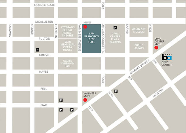
From the East Bay, take AC Transit to the Transbay Terminal at Main and Beale Streets, walk two blocks north to Market Street and take any outbound Muni underground line to Van Ness Station, then walk three blocks north to Grove Street.
415.989.2278 | TDD: 510.839.2220
BART lines stop at Civic Center station at Market and 8th Streets. Exit Civic Center station and walk two blocks west down Grove Street past Civic Center Plaza. BART typically runs until midnight daily.
510.817.1717 | TTY: 650.508.6448
From the South Bay, take Caltrain to the San Francisco station at 4th and King Streets, transfer to Muni and take the T line through downtown to Van Ness Station, then walk three blocks north to Grove Street.
415.455.2000 | TDD: 711
From the North Bay, take Lines 10, 70, 80, 92, 93 or 101 to Van Ness Avenue and Turk Street, then walk three blocks south to Grove Street. Check schedules in advance.
415.701.2311 | TDD: 415.701.2323
In San Francisco, Muni Bus Lines 5, 6, 9, 21, 47, 49 and 71 stop within four blocks of San Francisco City Hall. All Muni underground lines and the F streetcar stop at Van Ness and Market. Muni typically runs until midnight daily.
510.817.1717 | TDD: 605.508.6448
From the South Bay, take SamTrans to a Muni, BART or Caltrain connection, then follow the appropriate directions.


